
Imagine an autonomous vehicle (AV) approaching an intersection. The vehicle has to stay within its lane, identify which turns are allowed, and interact with pedestrians, cyclists and other vehicles. All of this is done through the technology embedded into the vehicle’s system. However, the road and the physical infrastructure in which the vehicle operates can make this task easier or harder. Faded markings, an obscured sign, or even an unusual intersection design can add uncertainty at a critical moment.
For road authorities, this raises a practical question: how well does existing infrastructure support the safe operation of AVs?
Readiness depends on the road and its context
There is no single characteristic that makes a road “AV-ready”. An AV may be required to navigate through a narrow road, identify any temporary changes in lane layout, or interact with pedestrians and cyclists. The effect of each individual feature depends on the capabilities of the vehicle, the conditions under which it operates and the surrounding traffic.
Thus, physical infrastructure readiness requires not just a checklist of required features, but rather an evaluation of whether road features enable safe and predictable AV operations. Road geometry, horizontal and vertical signage, pavement conditions and facilities for vulnerable road users are among the characteristics that need to be considered.
This process does not call for redesigning each and every road around AVs. However, improvements should support the safety of all road users, particularly in the early stages of AV deployment, where AVs will need to operate in mixed traffic environments with human-driven vehicles and vulnerable road users.
From road features to a framework for assessing readiness
FRODDO is assessing the physical infrastructure based on the Safe System approach: roads should help prevent serious accidents, even under challenging or adverse conditions. Our work identifies five guiding principles to prepare infrastructure for AV mobility.
The first is reducing risk through clear markings, visible signs, pavement, and regular maintenance. The second is supporting safe operation in a wider range of conditions, while recognizing that each AV can operate only within its defined limits. The third is making mixed traffic safer, since automated vehicles must share streets with human drivers, pedestrians, cyclists, and public transport.
The remaining principles look further ahead: designing infrastructure that can adapt as AV mobility develops, and connecting physical infrastructure with digital systems, such as roadside sensors and connected traffic signals.
The above-mentioned principles are integrated in the development of the Physical Infrastructure Readiness Index (PIRI), which serves as a framework for organizing and assessing the relevant road characteristics. The framework integrates different infrastructure measures so that conditions can be examined systematically and compared in the context of FRODDO pilots.
The objective of PIRI is to make it easier to see what works well, what is missing, and what should be done. However, the mere presence of an index score does not mean that the road can safely be used by every AV in every case. Readiness still depends and is assessed on the operating conditions of the vehicle itself and the outside environment (e.g. weather, traffic conditions).
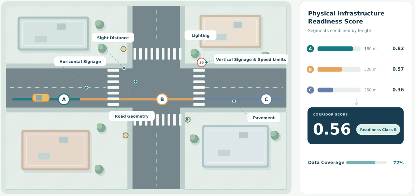
The assessment will be applied to FRODDO pilots, which have different characteristics and mobility problems. This will help show how a common framework can support decisions tailored to each location.
Authors: Katerina Vakrinou, Eleni Vlahogianni (NTUA)